A Conversation with the Earth

lightbulbideaHow many of us recognize the most important moment in our career? The instant when you realize exactly what you should work on, even if you don’t know where that might lead. It happened to a young theoretical physicist. He had earned a doctorate that tried to prove that gravity’s universal constant was neither universal nor constant. It was something of a failure. But then Xavier Le Pichon found himself in 1967 at a geophysics conference in Washington, listening to another young man – Jason Morgan – explain plate tecctonics and how the Earth’s crust was broken into solid plates, each jostling around, banging into one another, propelled by mantle flowing below the crust. Morgan explained the movements using a math tool created two hundred years earlier by the savant Leonhard Euler. Le Pichon knew Euler’s Theorem. He didn’t know about plate tectonics. But he would learn fast.

“Jason has a special gift for disorienting his listeners and this gift was especially well displayed on that occasion,” wrote Le Pichon. “Apparently nobody, including myself, understood the importance of what he discussed then.” The real turning point for Xavier Le Pichon came that evening while reading the lengthy speaker’s notes which Morgan had distributed. “As soon as I read it, I realized the importance of what he developed and dropped everything else I was doing.” Much later, Le Pichon said that reading Morgan’s lecture notes was the most important event in determining his career. He immediately switched from physics to geophysics. He was 29. His life’s work had started.

Unfamiliar with Jason Morgan, Leonhard Euler, and Xavier Le Pichon? A brief background will help. During development of plate tectonics theory, two physics problems kept arising. One was identifying a power source strong enough to move continents. We now see that as mantle convection. This blog has discussed convection before, so I’ll not go there just now. The other valid criticism of moving continents was the oft cited paradox of continents weak enough to break apart, yet strong enough to stay together while moving. Morgan figured out that if the crust was made of solid plates, parts would stay rigid for millions of years even while undergoing the stress of motion.

Jason Morgan's 1968 diagram of plate rotaion as constrained by Euler.

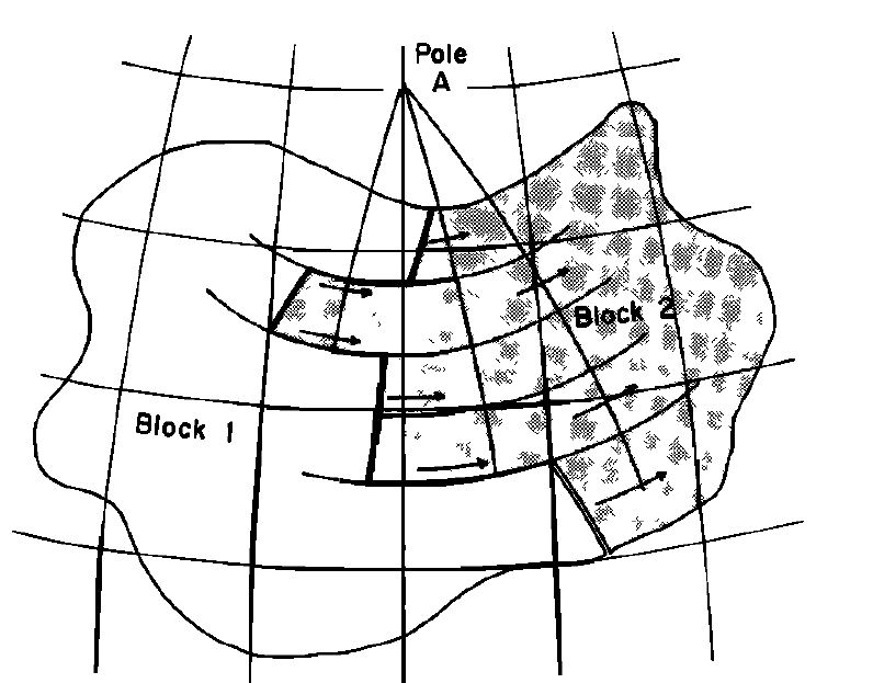
Part of Jason Morgan’s 1968 diagram of plate rotaion as constrained by Euler.

Morgan invoked a math theorem from Euler. Broken surfaces could move on asphere with a motion defined by a single axis of rotation. (“a block on a sphere can be moved to any other position by a single rotation about a properly chosen axis.”) It’s not so different from spinning a baseball cap, keeping one point in contact with the head – one can assume the rakishly charming look of a young gentleman with his sun bill pointing backwards. Morgan’s combination of poles, angular velocity, and vectors define plate motion. This is exceedingly important. It relates the various plates to each other, allowing predictions of the planet’s future look.

The geophysicists loved Morgan’s proposal – testable predictions and mathematics are the meat and potatoes of modern science. And it was useful to invoke the name of Euler, the creator of graph theory, infinitesimal calculus, the mathematical function, and the system used to compound the interest owed on your mortgage. The great Euler lent a measure of credibility to the new theory. Most significantly,  Morgan’s model of rigid rotating plates worked.

Jason Morgan came up with the idea that allowed rigid blocks, or plates, to become tectonic. Xavier Le Pichon set about rigorously applying the math and physics. He will be remembered for drawing the first map of the planet with plate boundaries sketched in place. But there is much more to his story. His life is among the most fascinating and diverse of all scientists.

Le Pichon was born in Vietnam, which was then French Indochina, where his father managed a rubber plantation. World War II started two years after his birth. Japan made a grab for Vietnam, but by the time it did, France had surrendered to Germany, Japan’s Axis partner, so Japan could not invade. But when the Allies won France back, France (and French Indochina) were again enemies of Japan, so the Japanese army moved in. Young Xavier (by then 7 years old) and his family were placed in a brutal concentration camp. They survived. But Xavier described those earliest years – before the camps – as idyllic. He was a French child, born in Vietnam, living in a thatched-roofed house, exploring the gardens and forests. As a child, he wanted to have a conversation with the Earth, to ask it questions about its age, its pieces and parts, its place in the universe. A conversation requires two parties. He said he wanted the Earth to answer his questions.

At 9, his mother moved the children to France.  Xavier excelled in physics, earned his PhD, then met Morgan and designed the plate boundaries. After immersing himself in Morgan’s work, Le Pichon divided the globe into six rigid plates, calculating their locations and rates of movement from Euler poles combined with palaeomagnetic and topographic data. It was a complicated amalgamation of extremely different types of data, but Le Pichon simplified the project and he made a brave assertion: the rigid plates combine both continental and oceanic crust in some of the units.

He drew a map – the first ever with plate boundaries – by boldly ignoring the ocean’s water.  His North American plate, for example, stretched from the centre of Iceland, across the western Atlantic Ocean, under New York City and Chicago, then nearly across the American continent. This was an important insight – geologists had just spent twenty years getting used to the extreme differences between oceanic and continental material, now it appeared these were sometimes fused together in an unexpected way. Now in his thirties, Le Pichon was one of the most famous of all scientists, interviewed, toasted, respected. He and Earth were immersed in the intimate dialogue he had sought since childhood. And then he stunned his friends and colleagues.

Simplified plate boundaries - now an iconic image of the Earth.

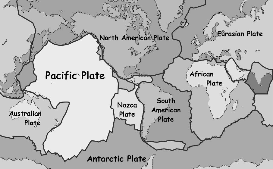
Simplified plate boundaries – now an iconic image of the Earth.

At age 36, Xavier le Pichon resigned from everything. All his university positions, all his committees. He moved to India with his wife and children. A devout Catholic, he went to work with Mother Theresa. He says he connected with the planet rather well, and it was now time to reconnect with people. So he worked with Mother Theresa. After six months, a friend – a priest – suggested that Xavier return to France. He should connect with people and he should continue his conversation with the Earth. He should find a way to do both. He took the priest’s advice.
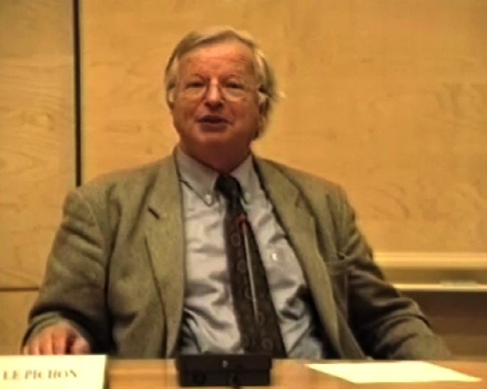
Xavier Le Pichon

Xavier Le Pichon

Le Pichon stayed connected and continued his conversation with the Earth. For the next 40 years, he lived with his wife and six children in a large community house that integrated mentally challenged adults in a family home. His foster home was part of the L’Arche Program, which he helped found, and which now has over a hundred communities scattered around the world. Partly to explain his commitment to the disadvantaged, he told journalist Krista Tippett in a 2009 interview, “Life has an extreme diversity and in this diversity is its richness.”**  Xavier Le Pichon, with his immensely diverse life, has lived one of the richest. Now in his late 70s, he continues his good deeds, more as a religious philosopher than a geophysicist. How does he feel about science and religion? “Science is science, and it doesn’t change whether you are a Buddhist or a Catholic or a Methodist,” says Le Pichon.  He is still looking for that ultimate conversation.

** (You may enjoy Tippett’s complete interview with Le Pichon.)

Posted in Biography, History, People, Philosophy, Plate Tectonics | Tagged , , , , | 2 Comments

A Bad Day at the Beach

Duncanson's Pompeii and Vesuvius, 1870.

Duncanson’s Pompeii and Vesuvius, 1870.

Today marks the death of Gaius Plinius Secundus, aka Pliny the Elder. He died along with 20,000 of his friends and neighbors. On August 24, 79, Mount Vesuvius exploded and Pompeii and Herculaneum were no more.

From the book, The Mountain Mystery, here is their story:

. . . Pompeii was doing just fine. The town had at least 130 bars, pubs, and taverns. Two hundred restaurants. Thirty bakeries. Good food, beaches, an amphitheatre, bath houses, and regulated, taxed brothels were attractions. People enjoyed a relaxed secular life. “Money is Welcome” was engraved on the floor of a trading house; “Profit is Joy” announced a sign in front of a merchant’s home. Bawdy graffiti and wall advertisements were everywhere, delighting and informing modern archaeologists as much as they did residents in the year 79 when it all came to an abrupt end.

The day before the city was destroyed had been a bright, hot, relaxing holiday. It was the Vulcanalia festival, though few people took their religious heritage seriously. The pious might have sacrificed something to Vulcan, god of fire. Many people started the day with the festival’s tradition of lighting a candle; some may have even committed a minor personal treasure to ash. But at the time, Vulcanalia was a day for sports competitions. It ended with a huge bonfire. Tossing live fish into the bonfire was part of the fun, but most people were not so religious. Perhaps if they had realized they were living in the shadow of violent devastation, they may have made more significant and solemn sacrifices to their volcano god.

But there was little to link the Vulcanalia customs to the mountain looming on the horizon. Other than a few ancient myths, there was no record of the mountain being dangerous. But in one legend, the Greeks told about Hercules fighting the fire god on Mount Vesuvius, “a hill which anciently vomited out fire.” Nearby Herculaneum was named for the battle that set Hercules against Vulcan; Pompeii, for the pumpe and ceremony, or victory procession, which Hercules celebrated after his victory over the fire god. But these were legends.

No one imagined the mountain could explode and obliterate their city. The last eruption was two thousand years earlier. It had destroyed Bronze Age villages, but that history had passed into mythology, and was hardly believable to Pompeii’s sophisticated first-century residents. By August 24, the Vulcanalian holiday was over; people were back at their routines, back at work. Then the mountain exploded.

Smoke billowed from the lush crater amid rumbles louder than thunder. At midday, a tremendous explosion blew apart the cone of Vesuvius, sending a plume of ash and pumice forty kilometres into the sky. The power of that single explosion released as much thermal energy as 100,000 Hiroshima atomic bombs. At the volcano, molten rock was launched at a rate of a million tonnes each second.  Farther away (but not far enough), ash began to fall like snow on Pompeii. Within minutes, the city centre was knee-deep in warm tephra that began to fuse into tuff. People fled.

Fortune Favours the Cautious

From relative safety across a bay, in the town of Misenum, the Roman admiral Pliny the Elder received a message that his friend Rectina was trapped at her seaside villa near the foot of Vesuvius. He immediately launched a fleet of galleys for the evacuation of the entire coast. Pliny himself set off with a handful of aides in a light ship to rescue Rectina’s group. He covered the 35 kilometres in a few hours, but as he approached the volcano, showers of hot cinders and pieces of rock pelted his boat.

Pliny reached Stabiae, about three hour’s walk from Pompeii but was trapped by falling debris, pumice floating in the water, and winds that kept him from rescuing Rectina. Pliny’s team was stuck; they spent the night on the beach as ash accumulated. In the morning, rocks and wind still blocked their escape by sea. The group tied pillows to their heads – helmets against falling rocks – and withdrew by land. Pliny, in his mid-fifties, sick and weak, decided to stay on the shore and wait for his crew’s return. He died on a white sail that his companions had set out for their admiral. They tried to make him comfortable before abandoning him. The group hiked out of the doomed spot, and returned to Misenum. Their safe return is how we know that while they were still at sea, just before reaching the spot where he would die, urged by his helmsman to turn back, Pliny responded, “Fortune favours the brave.”  Death, too, apparently.

We know much about Admiral Pliny’s heroic attempt to save his friend and about the manner in which Vesuvius erupted because at the villa of Pliny the Elder were Pliny’s sister and her bookish teen-aged son, remembered by us as Pliny the Younger. Much later, the junior Pliny wrote to his friend Tacitus that his uncle was likely killed by poisonous sulphurous gases. However, gases did not affect anyone else so it has also been speculated that the admiral suffered either a stroke or an asthmatic attack.

At the villa in Misenum, Pliny the Younger was taking notes on what he could see across the bay. He had been invited to join the rescue party, but he was a bit sickly, only 17, and he was no fool. His motto could have been fortune favours the cautious, as Pliny the Younger would live a long successful life navigating the intriguing labyrinth of Rome’s power, becoming wealthy and popular in the process. He not only survived the rule of various (and frequently contradictory) emperors, but consistently rose in rank all the while.

Pliny’s observations of the Vesuvius eruption give a splendid account of the power of the explosion. In his letter to the historian Tacitus, Pliny the Younger described an eruption that resembled “a pine tree – it shot up to a great height in the form of a tall trunk, which spread out at the top as though into branches, occasionally brighter, occasionally darker and spotted, as it was mostly filled with earth and cinders.” During the eruption, tremors forced young Pliny and his mother – the admiral’s sister – out of their house and into the courtyard, lest an earthquake bring the building down on them. After another sharp tremor, they left the village entirely. Pliny noted what seemed to be a small tsunami: “. . . the sea seemed to roll back on itself, driven away from the shore.”

Pliny the Younger matured into a gifted Roman lawyer, author, and politician. He was an incessant letter-writer. His notes are an important source for historians because Pliny illustrated the lives of the rich and famous when Rome ruled the western world. It was his friend, the historian Tacitus, who urged Pliny to put his Vesuvius experiences in writing. Pliny’s description is the world’s oldest written eyewitness account of a volcano. He wrote with such detail that modern volcanologists refer to similar eruptions as Plinian, in his honour.

A Plinian volcano - this one is in Alaska, but fit's Pliny's decription of Vesuvius erupting.

A Plinian volcano – this one is in Alaska, but fits Pliny’s decription of Vesuvius erupting.

A Plinian eruption is a volcanic explosion in which columns of gas and ash are blown high into the stratosphere, lifting enormous amounts of pumice. This type usually includes the loud explosive sounds and pyroclastic flows which warned, frightened, then smothered the citizens of Pompeii.

Posted in History, Religion, The Book | Tagged , , , , , | Leave a comment

Earth Rising

1966 Lunar Orbiter 1: photograph of the Earth, taken from the Moon.

1966 Lunar Orbiter 1: photograph of the Earth, taken from lunar orbit.

I was a child when the first photograph of the Earth, as seen from orbit around the Moon, arrived at NASA. Lunar Orbiter 1 was up there, scouting places for a future landing party of American astronauts. As an afterthought, the camera was turned earthwards and this iconic picture was radioed home. It was photographed on this date, August 23, in 1966. Sure, it was a fuzzy Earth. But it set our heads spinning. Soon people would be there. Then cities. I imagined that I might some day take a lunar vacation. Some day.

Also in 1966, some of the seminal papers about plate tectonics were published. It was the year when the majority of geologists – for the first time – accepted the idea of mobile continents. Until 1966, the consensus was mixed – drift was not yet considered the best explanation for our planet’s rugged terrain, mountains, ocean basins, volcanoes, and earthquakes. In 1966, plate tectonics took center-place in earth science.

There is a big connection between continental drift theory, the Earth, and the Moon, so it is interesting that the first photograph of planet and satellite posing together arrived in 1966, the same year plate tectonics really took off. The connection is this… For a long time, progressive geologists wanted to accept continental mobility (it explained the odd distribution of fossil homogies and geological structures that leaped across oceans) but geologists couldn’t believe there was any force weaker than God that could move continents. Some geologists, however, pointed upwards. The Moon could move continents. They were wrong, but their reasoning was sensible.

Astronomer George Darwin (Charles’s son) noted that if a celestial body had cruised near enough to the Earth when our planet was young, it was possible that a wad of crust the size of the Pacific Ocean could have been wafted into space. This theory – endorsed by many around 1900 – solved both the lunar birth question and the drifting of continents mechanism:  continents were seen as sliding to fill the hole left by the departed Pacific Ocean crust.

By the 1920s, Reginald Daly, a Canadian who headed Harvard’s geology department at the time, calculated that it was more likely that a wayward planetoid crashed into the Earth. Material was ejected, he figured, and this formed the Moon. A variation of this idea is still considered the best explanation for the Moon’s creation. In Daly’s first model of this scheme, he agreed with Darwin that the ensuing hole formed from the loss of earth material caused the continents to slide and fill in the gap. But in a decade, Daly questioned his own theory and was advocating mantle convection currents as responsible for moving the continents. He was right, however plate tectonics was still a crudely formed notion in 1940. It took another twenty-five years for enough evidence to pile upon the theory to breathe life into it.

And so we reach 1966. Space. Images of Earth and Moon as a team. And the whole concept of spreading seafloors, colliding mountains, subducting crust, hot spots and plumes. All of this,  just fifty years ago.

Posted in History, Non-drift Theories, Plate Tectonics | Tagged , , , , | Leave a comment

Dry Rising Crust

California desert, moving closer to the sun

California desert, moving closer to the sun

Dry, rising crust? No, not the morning toast coming up.  A paper released today by researchers at Scripps Institution of Oceanography shows that the American southwest, in the grips of a “once-in-a-century” drought, is rising because groundwater which normally keeps the crust weighted down has disappeared.

The numbers are amazing. 63 trillion (that’s 63,000,000,000,000) gallons – or 240 trillion liters – of evaporated (or pumped, irrigated, drank, and flushed) water is missing since the big drought began. This, say the Scripps people, has resulted in California’s mountains rising as much as 15 millimeters. When I wrote The Mountain Mystery, I explained the cause of rising mountains as plate tectonics, with a minor role played by thermal expansion. It never occurred to me to consider the loss of ground water.

How serious is the problem? Across the entire southwest, the average rise is only 4 mm. The Scripps scientists learned this from GPS data gathered between 2003 and 2014. The crustal rebound was general and correlated with the drought. But 4 mm is not much to worry about.  I once did a tiny bit of work on data from a superconducting gravimeter located in Ottawa. My contribution was a calculation of the effect of high and low pressure weather systems as they passed over the gravity meter. This was background noise that had to be removed from the numbers. The weight difference due to atmospheric changes alone (to say nothing of lunar tidal effects) causes the Earth’s crust to move about 25 millimeters every time the weather changes.

Although it is interesting to think about the west rising in sere agony, the planet is quite used to even more dramatic variations. And those oscillations create much more stress as they come and go over mere days, not months. The southwest drought is causing severe problems, but wrecked infrastructure and damaged buildings from a very slowly rebounding crust is not one of those problems. The research scientists were quick to add that this small crustal rise will have no effect on the probability of any impending California earthquake.

Posted in Engineering, How Geophysics Works | Tagged , , , | Leave a comment

Chile Shaking. . . it will happen again, of course

Beehives in Chile - shaken and stirred after the 2010 earthquake.

Beehives in Chile – shaken and stirred after the 2010 earthquake.

Earlier this week, geophysicists reported an analysis of the April 1, 2014, Chilean earthquake which killed six and displaced tens of thousands close to the epicenter near the Peru border. They said the new study is yielding information which may help predict future earthquakes in the area. At Magnitude 8.2, the 2014 Iquique earthquake was strong, but nothing near the intensity of the Concepción eathquake (M8.8) four years earlier. Researchers say the less intense rending actually gives more cues about the fault zone’s future activities than a stronger event would have given.

I missed the devastating 2010 Chilean earthquake by a few days.  Considered the world’s 6th most powerful earthquake (in recorded history), it rivaled the world’s worst – which was in 1960 and also in Chile. In the picture above, you can see what happened to a friend’s honey bees hives. His farm was 500 kilometres from the epicentre. I saw this apiary a couple of weeks before the big earthquake. It was doing fine then.  Funny thing about earthquakes. Everyone knows a bad one is coming. No one knows exactly when. But they can turn lives upside-down – human and arthropodal.

As a geophysicist, I didn’t want to actually see a major earthquake at work. I’m glad I left South America just before this one hit. It closed the airport, downed bridges, and trapped people in their homes. What Chile needed after the earthquake were doctors and rescue teams, not an inept seismic guy, if I had stayed. By the time the big one came, I was already back in Calgary.

My sister and I - among the Chilean bees.

My sister and I – among the Chilean bees.

Mild shakes sometimes forewarn of a major earthquake.  I was working in Peru and Chile on a short project in February 2010. My sister flew to Chile to join me half-way through my work there. We took a day to tour downtown Santiago, went into an old museum, a yellow, stucco building that had once served the mayor. On an upper balcony, the floor trembled a bit. I thought the shaking might have been caused by a slow rumbling train, or a delivery truck. But neither were anywhere in sight. The plaza held gently swaying palms and children rushing about on bicycles. But nothing big and quakey. My sister, who lives in San Diego, told me it was a small earthquake. She was right. The great central valley in Chile has such things at least weekly. It would be wrong to assume this one was an omen of the destruction that would arrive a few days later.

It was mid-summer in Chile. I was there to work, but in free time, I visited friends who kept honey bees as a business. Beekeeping is big in Chile. Bees pollinate fruits – especially avocados – and Chileans grow a lot of fruit. And millions of tonnes of honey are produced from clover, canola, avocados, and exotic trees like quillay, ulmo, and tineo. At a honey exporter’s shop – a business that ships 5 million pounds of honey each year from a bright and modern plant – I learned even more. In the laboratory, I met the quality supervisor. She was a young lady with a chemistry degree. She produced samples of Chilean honey for me to examine.

Drums of honey - smashed, shaken, and stirred.

Drums of honey – smashed, shaken, and stirred.

“This,” she said, “is clover, from Aysén. Far south.”  Aysén, near the southern tip of Chile, is where beekeepers from Chile’s northern valleys truck their bees in the spring. After Aysén, the next stop is Antarctica. The chemist also showed me black-colored honeydew collected from pristine forests along the Andes, golden honey from the northern desert, and dark molasses-flavored honey from avocado groves around Santiago. Before I left, I was escorted around the shop, past honey in neat steel barrels stacked drum-on-drum three levels high. A ton of honey in each of the hundreds of stacks. A week later I heard that 2 million pounds of honey were lost – barrels broken, honey leaked on the concrete floor.

Honey wasn’t the only thing spilled. 125 million bottles of wine were washed away. In some towns “the streets ran red” with spilt wine, according to the Santiago Times. We tend to forget the incidentals of earthquake damage. Millions of pounds of honey; millions of bottles of wine. Quite rightly, it is human loss we grieve – during the 2010 Chilean earthquake, 600 people died. Worst hit was the coastal city of Concepción – Chile’s second largest city.

 On February 27, 2010, an oceanic tectonic plate disappearing under South America took a deep dive. A 600 mile stretch of the Nazca Plate jerked into the subduction zone, settling farther under South America. Meanwhile, in a violent rebuttal, parts of the South American tectonic plate lurched west, up over that wedge of ocean crust. The total energy of the 2010 Chilean Earthquake was equal to 240 million tons of TNT.

Concepcion, Chile - 2010

Concepcion, Chile – 2010

Near the 2010 epicenter, Concepción, jumped an amazing three metres (ten feet) west. The whole city, in one big piece, was conveyed along a thrust-fault. The earthquake shifted almost a million people, their houses, cars, fire stations, and schools, roads, trees, and parks – a whopping three metres. If you lived in Concepción, you’d think your neighbour’s house was where it was the previous Friday evening. But you’d be wrong. According to GPS tests run by geophysicists from Ohio State, the entire city had lurched westward.

If you had the misfortune (and talent) to jump up into the air the moment the earthquake struck (and stayed there half a minute), you would have come down some distance from where you’d started. Well, actually, you would have dropped where you started, but your neighborhood would have moved under you.  Meanwhile, three hundred kilometres away, at the capital of Santiago, the city and its five million people were lifted and dropped about half a metre west. And all over the country, bee hives were lifted and dropped from their pallets and perches.

Chilean earthquakes will repeat their jerks and lurches for millions of years, finally stopping when South America has devoured the Nazca Plate. Most recently, on April 1, 2014, the north coast of Chile was badly shaken along the northern edge of the subduction zone where the Nazca tectonic plate slides under the South American plate. Not as severely as the 2010 earthquake, the M 8.2 2014 Iquique earthquake was also not as strong as the 1877 M 8.8 in the same area. This sheds light on the formation and distribution of quakes along the busy border between the Nazca and South America plates.

The big finding, according to an August 2014 article in Nature, is that earlier predictions that the next major Iquique earthquake would measure 8.8 because the last big one, 150 years earlier, was also 8.8, were wrong. The weaker strength of the 2014 quake apparently took most researchers by surprise. It tells them that the worst scenerio is not always the one that will happen – even if people have been waiting 150 years. It also suggests that not all the stress was released on April Fool’s Day in 2014. More is yet to come. Finally, this is a reminder of how little we know about predicting earthquakes.

Posted in How Geophysics Works, Plate Tectonics | Tagged , , , , | Leave a comment

Who’s Got Mantle?

Buzz Aldrin, setting up a seismic detector in 1969. The solar systems's first luno-phone.

Buzz Aldrin setting up a seismic detector in 1969 – the solar systems’s first luno-phone.

NASA has reprocessed the Apollo missions’ old lunar seismic data. The data is from 1969 through 1977, the latter being recorded by equipment still active long after the last astronaut went home. This is old seismic data. Reprocessed, it tells new stories. In my own work, I have reprocessed ancient earthly seismic data (some from the 1950s!) and found similarly dramatic improvements. Such data sets are sharper, clearer, better focussed. In recent years, powerful computers and tremendously improved algorithms have made old data sing and dance. In the case of the lunar seismic, we now have a clearer picture of the Moon’s crust, mantle, and core.

The lucky American men on the moon shot explosives ranging up to 2.5 kilos (5 pounds) at the lunar surface, sometimes using thumpers, other times launching mini-grenades. Their geophones (luno-phones ???) were often poked in straight lines, much as scientists have done during earthly oil exploration in places like Siberia and downtown Los Angeles. At first, the lunar tests yielded little more than shallow results. But apparently, the record-lengths were several seconds longer than needed to acquire data limited to just describing near-surface lunar horizons. Now the parts of the seismic records that picked up reflections bouncing from the core have also been reprocessed and reexamined.

Renee Weber, a space scientist at NASA’s Marshall Space Flight Center (Huntsville, Alabama), said that her team applied modern seismology techniques developed for terrestrial data “to this legacy data set to present the first-ever direct detection of the moon’s core.” This is big news because it revealed a big surprise.

Choco-earth; choco-moon: both are equally edible.

Choco-earth; choco-moon: both are equally edible.

The big surprise (to me at least) is the similarity between Earth and Moon innards. The NASA team is suggesting that the Moon possesses a solid inner core of iron-rich material. The lunar inner core is surrounded by a squishy outer core, much like the Earth itself has. And much like a good-quality chocolate-covered cherry. Should you ever have trouble remembering the phases of the inner-earth, imagine a choco-cherry. Think of the solid cherry (the inner core) of the candy, surrounded by gooey liquid (the outer core), then the creamy white fondant (mantle), topped with a thin chocolate layer (the crust). The proportions are off, but the order and state of the material is right. It appears that the Moon has the same general internal structure. Maybe with one deviation, which we will come to in a moment.

So, here’s the big picture: The Moon has an Earth-ish interior. First, a 240-km radius iron inner core. Then, up to 330-km, a liquid outer core. Next, something unearthly, sort of out-of-this-world, if you will. The Moon has a sloppy molten layer surrounding the outer core. It seems to hold some interesting elements, such as sulphur, perhaps even calcium and cheese mold. Beyond that is a conventional rocky plasticized mantle and then a basaltic crust. Below, you can see a side-by-side Earth-Moon comparison.

Earlier, I mentioned that seismic data was recorded on the Moon until 1977. The last Apollo mission was in 1972. With no men on the moon to thump thumpers and lob grenades, the seismic equipment went into a passive phase, but continued to transmit seismic records intermittently for another five years. The energy source after the humans went home was mostly meteor impacts which sent shock waves echoing through the lunar depths. These were sometimes large energy bursts. Falling rocks powered low-frequency seismic waves which can travel farther and deeper and allow better signal-to-noise ratios from boundaries between the lower mantle and the lunar core.

Earth, left, Moon, right: their cores are showing.

Earth, left, Moon, right: their cores are showing.

Posted in History, How Geophysics Works, Space | Tagged , , , , , | 1 Comment

Who gave Santa all that Oil?

Putin, skyping friends in Siberia.

Putin, skyping his friends in Siberia.

This weekend Russia announced that the world’s most northerly oil well was about to spud.  Vladimir Putin did the actual announcing himself from his summer vacation palace in Sochi. (He is the guy behind the big desk, above.) He was linked by satellite to his friend Igor Sechin, head of Rosneft, and Exxon’s Glenn Waller, whose company is a joint-venture partner and is doing the actual drilling. (Those gentlemen were on the screen at the right, above.)

In a show of solidarity that brilliantly demonstrates – despite personal sanctions against Igor Sechin, and despite outrage over Russia’s role in the Ukraine, the killing of 300 (mostly Dutch) air passengers, the West’s finger-pointing, and general angst about the new Soviet model – regardless of all this, America’s Exxon and Russia’s Rosneft showed they can nevertheless play nicely in the Arctic. So kudos to them. (This is not a political blog, but NASDAQ’s website has some thoughts on the sanctions.)  I will ignore Continue reading

Posted in Exploration, Oceans, Plate Tectonics | Tagged , | Leave a comment

All Aboard the Barracuda

USS Barracuda, plying the Devil's kitchen.

USS Barracuda, plying the Devil’s kitchen in 1936.

Maurice Ewing was a Texas-panhandle farm boy,  became a geophysicist, and then and oceanographer. He conducted the first marine seismic acquisition, inventing the equipment he needed as he sailed the oceans. I find it odd that a lad from the grasslands spent years at sea, but apparently Ewing himself never found it strange. Early in his career, in 1936, he found himself aboard the Barracuda, an oceanography research submarine plying the Caribbean. Also aboard were two other phenomenal young geophysicists, men who would revolutionize the way we understand the planet. These were Edward Bullard, of Cambridge, and Harry Hess, from Princeton. Had the Barracuda floundered, Continue reading

Posted in Exploration, History, Oceans | Tagged , , , , , , | Leave a comment

Zero Degrees of Kelvin

My book, The Mountain Mystery, is not kind to the great physicist Lord Kelvin. I feel a bit uneasy admitting that in my research on the brilliant fellow, I just could not get comfortable. I wouldn’t have been his friend. And I am quite certain Lord Kelvin would have had no spare change for me, either. I picture him doing his civic duty as an old man, addressing the unwashed masses at one of his Christian Evidence Society rallies, a group that directed its activities towards the “lower grades of society, to save them from infidelity.” At one such meeting, he educated the public on the age of our planet. “Not older than twenty million years,” he told his audience in 1900. By then geologists were daring to disagree.

Lord Kelvin, born William Thomson (1824-1907), would have been rightly heralded as the greatest physicist of his time, perhaps all time, if his time had ended before he turned 50. Some have said that during the first half of his adult life, he could get nothing wrong. Every notion emitted from under his tall black hat carried a deserved air of cleverness. Some go on to say that during the second half of Lord Kelvin’s life, he could get nothing right.

First the shining star. William Thomson (his name while he was still clever) figured out thermodynamics. He understood heat transfer and invented the maths and formulae needed to explain it to others. That second law of thermodynamics – the one that says the universe is winding down and will expire in stark cold entropy? Thank Thomson for that. He worked on electrical signal transmission, helping make long-distant telegraphy possible. He was an engineer and a director of the first trans-Atlantic telegraph cable. Thomson made sense of heat, convection, and conduction. At age 24, he calculated the coldest possible temperature, the state where molecular motion stops and physics becomes bizarre. Other scientists named a new temperature scale for him, the Kelvin scale, with Kelvin’s coldest cold (“absolute zero”) as the base for that particular thermometer. Rather than calling that frozen place minus 273.15 Celsius, it is defined as Zero Degrees Kelvin.

One wishes William Thompson had retired early. Queen Victoria peered him for his loyal opposition to Irish rights and Home Rule, and for his political conservatism. As Lord Kelvin, he droned on and on about things he clearly had not thought much about. By his mid- and later years, he was dismissing X-rays as a hoax and shortly before the Wright brothers great experiment, he was telling the newspapers that flight would never be possible. (“No balloon and no aeroplane will ever be practically successful,” he told Garrett Serviss of the New York Journal in 1902.)  On the eve of the great physics revolution kicked off by Einstein, Thomson is claimed to have said, “There is nothing new to be discovered in physics. All that remains is more and more precise measurement.” Physics, thought Kelvin would become a dead science, a place where engineers tinkered with equipment and added a decimal point a decade to already known constants.

In regards to earth science, Lord Kelvin was an unfortunate thorn. He believed the Earth is cooling from an original hot sphere. From his heat conduction calculations, he figured Earth could not be more than perhaps 20 million years old. Likewise the sun. With no knowledge of radiation, fission, or fusion, Kelvin guessed the sun was powered by gravitational collapse. It could not maintain its heat for more than a few million years and must be nearing the end of its reign.  But geologists and evolutionary biologists needed a much older planet to explain the slow gradual processes they observed. Hundreds of millions, perhaps billions of years, were required. Kelvin was adamant. Unyielding in his wrongness.

A brave assistant, John Perry, tried to convince Kelvin that mantle convection (a new idea) may be involved in the Earth’s heat distribution. If it was, it could mean the planet was over a billion years old. But Kelvin insisted the globe is a solid homogenous ball of conducting heat, not differentiated into layers and certainly not convecting heat to the surface. Kelvin probably ruined his insubordinate’s career after Perry dared publish the idea in Nature. Had Kelvin given the idea some real thought, he would have hastened the acceptance of plate tectonics and he would have made a final grand contribution to science. Alas, he was by then an old Lord with no new tricks.

Posted in Biography, History, How Geophysics Works | Tagged , , , , | Leave a comment

Seismic Saves the World

The Pacific Ocean, before the 1963 Test Ban Treaty

The Pacific Ocean, before the 1963 Test Ban Treaty

Remarkable that we haven’t blown the planet to bits with an atomic bomb.  Not yet, anyway. An atmospheric nuclear test ban went in effect August 5, 1963. Exactly 51 years ago today. And almost 20 years after Hiroshima and Nagasaki were obliterated. The 1963 Limited Nuclear Test Ban Treaty – signed by America, Britain, and Russia – limited nuclear testing to underground blasts. Atmospheric, outer space, and underwater tests were prohibited to put “an end to the contamination of man’s environment by radioactive substances.” Good idea. But further nuclear bomb treaties were made possible because of an unlikely discovery made by a geophysics grad student.

A seismic shift towards world peace began when seismologist Jack Oliver, working at the Lamont Earth Observatory just outside New York City noticed some peculiar wiggles showing up on his seismometer. Several things seemed immediately odd about the wiggly shapes on his strips of paper.

The seismic activity arriving in New York appeared to be coming from the deserts of Nevada, a place where strong earthquakes are rare. The second peculiarity was that the seismic wave form, the wiggle’s shape, was quite different from recordings of normal earthquakes. A seismogram from an earthquake starts with strong sideways shear waves, accompanied by weaker pressure waves. Pressure waves are as you might expect – forward pressure along the ground, while shear waves result from side-to-side shaking. During an earthquake, rocks break along a fracture zone, shearing raggedly. That’s why the arriving shear wave is strong and shows side-to-side motion. But Oliver’s records began with a sudden sharp forward-moving pressure wave instead.  The third strange thing about the seismic record was that the signal seemed to radiate from a single point, not a fault zone. Jack Oliver deduced that the single-point was a nuclear explosion in the Nevada desert. Oliver was inadvertently spying on a top-secret test of American atomic weaponry, 4,000 kilometres away.

Jack Oliver admitted he was a bit nervous when he realized what he had discovered. He had the practical common sense of a midwesterner and suspected the army might not be pleased when they learned that a civilian was looking over its shoulder. Oliver was born into a small heartland community, Massillon, Ohio, a steel town just west of the tire factories of Canton. He had been a talented football player, a member of a high school team coached by Paul Brown, later the first coach with a professional football team named after him – the Cleveland Browns. Paul Brown’s help and Jack Oliver’s talent earned him a sports scholarship. But university was interrupted in his second year by World War Two, which put Oliver in the South Pacific. He was thirty years old when he finally finished his geophysics doctorate at Columbia, and accidentally uncovered a way to monitor secret atomic weapons tests.

Rather than being arrested for eavesdropping on the military,  Jack Oliver was soon fêted as a celebrity scientist – the world’s expert on detecting nuclear explosions. He showed that seismic waves from an atomic bomb could be recorded by any backyard tinkerer, anywhere on the planet. Secretive nuclear tests could no longer be hidden from scrutiny. Oliver was invited to the White House. Eisenhower asked him to advise on the first draft of the Nuclear Test Ban Treaty. In the late 1950s, Jack Oliver was a delegate to negotiations in Geneva. With his discovery, American scientists could monitor Russian activities (and, of course, vice-versa) making nuclear tests verifiable and a non-proliferation treaty possible. Geophysicists triangulated blast locations and estimated weaponry power.

There’s more to the story – the American government asked scientists to install monitors all over the world. Their new data proved Tuzo Wilson’s theory of transform faults and gave Jack Oliver and his team proof that subduction plates disappear into the Earth’s crust. . .  This tale continues in the book, The Mountain Mystery.

Posted in Biography, History, How Geophysics Works | Tagged , , , , | Leave a comment