We love the superlative – biggest/smallest, widest/narrowest, and more often than not, the tallest, heaviest, strongest rather than the shortest, lightest, weakest. Not many travel posters feature the ‘averagest’ waterfall, tree, or lake. So it might seem against human tendency to seek out the center. But the center has got it’s own appeal, especially when attached to something big: the centre of the Universe, or the center of the continent.
 In the 1800s, many states tried to locate their county seats near the county center. The county seat usually hosted the county government, the county court, and the county jail. Being equidistant from all villages, it seemed fair. In my own childhood home county of Mercer, Pennsylvania, the town of Mercer became the county seat. I was 16 when I drove our old farm truck to Mercer so I could take my driver’s exam. I remember my father clutching his passenger door the whole way there, rather sure that he wouldn’t survive my poor driving, though I did come home with permit in hand. It was lucky for him that the county seat was centrally located. Had it been in Grove City, our trip would have been ten minutes longer. As you can see in the map, the county seat is near the county center (actually 7 kilometres south, but there is nothing but woods at the actual center).
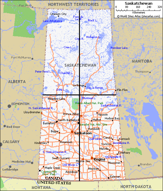 It’s not hard to find the geographic center of a square and Mercer County is very nearly a square. Later, I lived in Saskatchewan, Canada. It’s another jurisdiction which presents little challenge when looking for its center. Saskatchewan’s motto, “Easy to draw; hard to spell”, tells it all. The only surprise with Saskatchewan is that the center is ‘way up north’ – 99% of Saskatchewanians live south of center. The northern half is sparsely populated Canadian Shield while the southern half of Saskatchewan has been flattened out to accommodate millions of acres of wheat fields. And a million European settlers.
 But what do you do with a place like Croatia? Croatia is one of my favourite countries. It’s got over a thousand beautiful Mediterranean islands, vast rolling vineyards in the north, an old Hapsburgian baroque capital (Zagreb), and a geographic center located in another country. To visit Croatia’s geographic center, one must travel over to the Serbian-controlled Republika Srpska, an enclave within Bosnia i Hercegovina. The very definition of balkanization. Obviously few Croats would use the geographic center to define their country’s center, but might enlist a cultural, historical, or even population center instead. Probably the appropriate center of Croatia would be its center of mass, something we’ll discuss soon.
 For years, the geographic center of North America has been described as this stone and mortar obelisk in Rugby, North Dakota, 60 kilometres south of Manitoba, Canada. I used to drive past the monument a couple times a year back in the days when I owned homes in Florida and Saskatchewan. Here I am, thirty years ago, daughter in arms, standing at the center of North America. Had the monument been ten kilometres off Highway 2, this photo would have never happened. But there it was and so was I. In 1929, a US Geological Survey geographer cut out a cardboard map of the continent and balanced it on his finger. The balance point – the center of the continent’s mass (if all the mass of the continent were smeared around equally) was taken as the center of North America. He found the spot near the North Dakota towns of Balta and Orrin, 30 kilometres southwest of Rugby. Both towns claimed to be the center, but Rugby sent an application to the US Patent Office to trademark the title, leading suckers like me to believe we’ve been to the center when, in truth, we hadn’t. But the laugh was on Rugby last summer when the trademark expired and a bar owner much further south in North Dakota bought it. So, briefly, Hanson’s Bar became the continent’s center. But hold on to your cowboy hat, the center is moving again.
Geographers with a sense for plate tectonics might choose to use the continental shelf as the outer boundary demarcation, pushing the center east. Others may omit Central America, claiming the extremities of southern Mexico as the bottom of North America. This would slide the center well into Canada, especially if Canada’s claim of the North Pole proves that North America goes that far.
Now a State University of New York (at Buffalo) geographer wants to redefine North America’s center. Peter Rogerson has mapped a spot 175 km southwest of Rugby, North Dakota. His center is near the center of Center, North Dakota. The town – population 571 – got its name when it was determined to be the geographic center of Oliver County, North Dakota and thus chosen as the county seat, back in 1902. Center, ND, is only 30 kilometres north of Interstate 94, so Americans travelling from New York City to Seattle may consider taking an hour’s detour to stop, look, and have coffee at the Square Butte Diner in Center. Or maybe not, since the trademarked Center of North America(TM) is actually at a bar 115 km east. But an ambitious family would stop at both, I suppose.
Why move the center from Rugby to Center (or legally, Hanson’s Bar)? For that, we turn to Dr Rogerson’s wonderful 2015 paper, “A New Method for Finding Geographic Centers, with Application to U.S. States“, published in The Professional Geographer. Rather than cutting up a cardboard cereal box, as the USGS scientists did in the 1920s, Rogerson used a computer and an algorithm that:
“…minimizes the sum of squared great circle distances from all points in the region to the center. This entails
(1) projecting regional boundary points using an azimuthal equidistant projection,
(2) finding the geographic center of the projected two-dimensional region, and
(3) then transforming this location back to a latitude and longitude.
This new approach is used to find the geographic center of the contiguous United States and to provide a new list of the geographic centers for U.S. states. This list improves on the widely used but inaccurate list published by the United States Geological Survey in 1923.”
This all makes sense, of course. One wonders why it took almost 100 years to sum the great circle squares. I hope that Professor Rogerson can apply this to Croatia and move its mathematical center from Bosnia to Lekenik, Croatia, the village which Norm Jewison chose as Anatevka when he filmed Fiddler on the Roof. If this can be done, geographers will have proven their enduring value.

Is Lekenik Croatia’s real center of balance?

Well, I guess the Croats weren’t so far off the mark with Zagreb as their capital. The entire region suffers a deficit of vowels, though. I think that throws many calculations off their mark, geographic and political.
LikeLiked by 1 person
Nice. Rgrdng lck f vwls:
Croats often use the letter ‘r’ as a vowel – krv, blood; prst, finger; grm, bush; and many others. It’s a lovely language and not too hard for us unilingual English speakers.
LikeLiked by 1 person